
Every summer, wildfires are reported in the news around the world. Spain knows this phenomenon well and this time the worst affected area so far is La Palma, an island of the Canary archipelago in Spain, located off the northwest coast of Africa.
This island is no stranger to natural destruction. The population is reliving the days of drama they experienced in 2021 when the Tajogaite volcano erupted for 85 days — the lava affected homes, crops and land in El Paso and Los Llanos.
The views from Tazacorte are not comforting #IFPuntagorda #LaPalma pic.twitter.com/YsKbj3ODXb
— Christophe Berg | Nomadic Trail Runner (@kristofberg) July 15, 2023
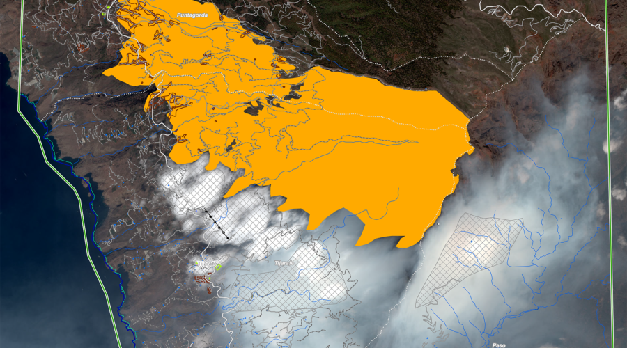
This year’s fire has consumed more than 4,600 hectares and 20 buildings in the municipalities of Tijarafe, Garafía and Puntagorda in the northwest of the island. Due to the rapid spread of the fire, about 4,200 residents were evacuated during the first few hours.
On site, more than 500 people have been actively working since the weekend to minimize the damage of the fire that originated in the area of El Fayal. Firefighting teams have managed to retreat the flames; however, the fire has already caused serious damage to the area and entered the National Park of La Caldera de Taburiente.
High temperatures and human intervention
Spain’s meteorological agency warned that high temperatures and drought are increasing the risks of forest fires. Southern Europe has been rocked by a heat wave in recent days that continues to dry out fields.
Although the La Palma fire spread rapidly on Saturday, July 15, due to weather conditions, wind and the heat wave, authorities are not ruling out human intervention at ground zero.
The fire may have originated due to the burning of a garbage container at a night party, said Guardia Civil sources. This group would have failed to comply with warnings from the authorities not to set fires due to the high temperatures.
Wildfires in La Palma continue:
A wildfire on the Spanish island of La Palma has led to the evacuation of approximately 2,000 people amid a scorching heat wave in Spain. The fire has destroyed around 4,500 hectares (11,120 acres) of land and caused the destruction of 12 houses.… pic.twitter.com/4eIWdyCO6F
— Volcaholic 🌋 (@volcaholic1) July 16, 2023
A large plume of smoke and ash
The smoke has traveled more than 130 kilometers and is large enough to be detected from space. NASA satellites and the State Meteorological Agency have shared images of the path. The smoke plume reaches almost as far as El Hierro, another island belonging to the Canary Islands archipelago.
The residents of the northwest part of the island have again experienced ash rain, which reopens the wounds of the volcano. Some of those displaced by the fire today were also affected by the volcano’s eruption. Instructions are again encouraging them to wear face masks as a safety precaution.
Authorities have allowed many of those affected in the area to return to their homes, due to the favorable progress in recent hours. Another group remains in municipal shelters with assistance from the Red Cross.
The evacuated zones belong to El Fayal up to Torre del Time, the area of Hacienda del Cura, Barranco de Jurado, facilities of Roque de los Muchachos and sectors of Tijarafe and Puntagorda. Likewise, domestic animals and livestock were evacuated from these areas and are being sheltered in El Paso and Los Llanos.
🔵Ultima Hora La Palma Ahora Mismo pic.twitter.com/57FNLEPyAP
— CN8 Noticias Canarias (@infoNCanarias) July 15, 2023
While firefighters continue to work to prevent reactivation and progression towards the national park, one of the helicopters of the Ministry of Environment’s Forest Fire Reinforcement Brigade crashed in Tigalate, near the El Cabrito volcano.
The helicopter, which was discharging water to refresh the area, reportedly lost power due to a problem with the tail rotor. The two pilots, a Frenchman and a Spaniard, specialists in this type of task, had only minor contusions and were treated at the scene and later transferred to a local hospital to rule out major contusions.
The latest
Although the fire is not yet under control, authorities have indicated that weather conditions could help, due to humidity and lower temperatures. So far, the more favorable conditions, such as the absence of wind and the rise in humidity, have slowed the advance of the fire.
This Tuesday, work is concentrated on extinguishing the fire in the Caldera de Taburiente National Park, an area that is difficult to access with complicated orography. Meanwhile, the other two fronts of the fire are perimetered.
The work is hampered by the presence of smoke as a result of thermal inversion, where the air cools down with altitude. The teams on the ground are rotating personnel every two hours due to poor air quality and problems on the ground.
Image: Copernicus Emergency Management Service